Week 1: Dimensions of Earth
March 5, 2024
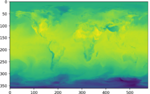
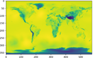
Welcome back! Last week I told you guys about how I’m going to generate images of exoplanets. But there needs to be a starting point… Earth. Using General Circulation Model (GCM) files of Earth, which (as a little recap) include information about the atmospheric composition, and some Python, I created these 2D images, and I’m going to let them speak for themselves a little bit:

Cool, right? Above, we have ourselves a temperature map of the Earth, and below that we have a pressure map. These are from quite a few kilometers above the surface of the planet, and I am able to vary the distance above the planet I image from. For a better understanding, think of the atmosphere like cake, and different information is revealed at different layers.
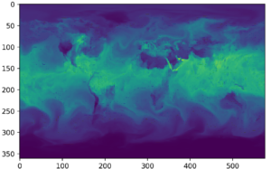
Now for the most interesting (and most useful) part: relative humidity maps. These are essentially maps of cloud coverage, and being able to include this kind of data for exoplanets is critical for a more accurate analysis. But for now, here’s Earth’s relative humidity map:

With these base generators, I’ll be able to create 2D maps of exoplanet Trappist-1e, which are similar maps to these. However, I expect the resolution of the image will not be as clear since Trappist-1e is 41 lightyears away from Earth… Nonetheless, I’m excited to see what they look like!
“I’m a alien, I feel like changin’ the weather” – Yeat, bigger thën everything.
Tanvi Deshmukh

Leave a Reply
You must be logged in to post a comment.