Week 3 — Steady Progress
March 21, 2025
At the start of this week, I made sure that all the sections of the trail that I had worked on were fully complete after all my work last week attaching photographs to plant pins. This week, I ended up walking a really dense forested part of the trail 3 times, and finally on the last try didn’t notice any missing photographs, or even plants altogether. After that, I moved on and continued mapping plants farther along the main Sabercat Creek trail in both directions. Based on what I learned last week, I made sure to stay organized and each time I moved on to a different section of trail, I created a new layer on the map. I managed to pin the bulk of the plants in Restoration Site 4 of Sabercat Historical Park.
At this point, I’ve kind of made some decisions that will influence the rest of my project. With my photographs, I have decided to take multiple kinds of pictures for each plant. I try to take a picture that shows the plant visible from the trail, so people can easily figure out which plant they are looking at from the pin on my map. But at the same time, if this picture doesn’t provide enough detail I go close to the plant to take a more detailed photograph of the leaves, blossoms, and flowers. I’ve also worked on compiling all my pictures into folders on the Photos App so that my external advisor has access to images the city needs to document the various plants in their restoration sites (the same sites I spend a lot of time mapping).
With regards to pinning things on the map, I have kind of figured out how to identify trees from how they look on the satellite. For example, a dense dark green is typically a coast live oak, and a small mass of light green is usually a California Black Walnut. So I can kind of pick apart trees like this. In other areas that are more dense or larger trees cover smaller trees, I measure the distance to plants from objects. Then, I find my reference and object and use the Google MyMaps measuring tool to get the accurate location my new 100 ft tape measure. Some areas, have both dense plant cover on the satellite, and no frames of reference. In that case I try and see whether the plant is in line with a house in the distance or anything remotely close by like a house. I then go on maps, and ditch my tape measure. Even my external advisor told me she often ends up resorting to this same system!
Finally, for now, I am keeping things on the map simple, Most of my pins are blue and look the same. Once clicked on the specifics of each plant are provided. Originally, I wanted all the different kinds of trees to be color-coded and to even have different logos for invasive/native/non-native plants. But each of those extra clicks really adds up when I am working with tens of thousands of plants. So, after talking to my internal and external advisor, I’ve decided to focus on getting most of the plants pinned, and simplicity. if there’s time at the end, maybe I’ll realize my dreams.
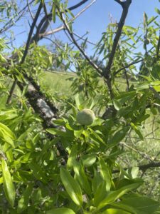
Overall, this week has been super fun. I can now recognize most of the plants without using the Camera App on my phone. But today, something really exciting happened. After marking many of the same plants over and over again, I was pleasantly surprised to see a completely new plant with what appeared to be seeds, blossoming on a part of the trail I’d never seen. It was a an Almond tree, a reminder of the park’s—and Fremont’s—larger agricultural history. Today reminded me that the trees around me and the land around me carry a history, and it was exciting to see an almond tree and reminder of the Silicon Valley’s deeply agricultural roots.
This week I worked to pin some really plant dense areas really accurately!

Here’s a picture of the Almond I found:
Here’s some of the work I did to get organized:

See you next week!
Leave a Reply
You must be logged in to post a comment.