Week 9: Finishing up, part 1
May 3, 2025
Hi everyone, and welcome back to my blog. This will be a quick, short one because I’m super busy trying to get everything done.
This week, I dove into the bulk of the data analysis and case study portion of my project. I started off the week downloading NetCDF files for the five case studies I presented in last week’s blog. However, when I opened up the charts for Alberto 2000, I was not seeing any signature of an atmospheric river.
That’s when I realized that the Rutz AR catalog, although useful for narrowing it down a lot, was still not the most optimized for AR detection, since it had only three main criteria—an IVT of 250 kg m-1 s-1, a width of under 1000 km, and a length of over 2000 km. This meant that it would call the normal tropical wave “train” in the tropics an atmospheric river, which it is not.
As a result, I had to retrieve the more “accurate” Guan and Waliser catalog (basically more constraints) and then review all 48 events I had recorded in my logbook. Four hours later, I was able to cut that list from 48 to 28. In that process my case study list also changed, replacing Alberto 2000 with Joaquin 2015.
I’m currently working on the analysis part of the individual case studies, and the Python program for the charts is in progress. (Refer to last week’s blog if you’re not sure what I’m talking about). For the record, here are the variables that I’m going to be looking at the most for the case studies, as shown by my data requests from the Copernicus Climate Data Store for Allison 2001:
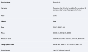

That seems like a lot. However, don’t worry, I’m only really looking at maximum/minimum values over a time frame. Some variables, like total cloud cover or the water vapor flux components, are simply for verification. Other variables, like significant wave height, precipitation, and 10m wind, will give me an idea of the effects of the AR events, simply reinforcing the rationale for this project. The rest, including everything in the first image, will be used to observe the conditions surrounding the tropical cyclone, and I hope to find some sort of trend between the five cases.
Next week will be BUSY. I’m going to be working on the weekend to get things done, and hopefully have a poster ready by Wednesday (Thursday at the latest). See you next week!
Leave a Reply
You must be logged in to post a comment.